Welcome to the most beautifull canyon in the world (Time to confess, i am very happy write this article, the object is very beautifull, the colour is so colourfull and amazing). Yes, we are going to talk about the most colourfull brightest and amazing canyon in the world, Antelope Canyon. Antelope Canyon is the most-visited and most-photographed slot canyon in the American Southwest. It is located on Navajo land near Page, Arizona.
A long time ago, herds of pronghorn antelope roamed freely in Antelope Canyon, which explains the canyon's English name. It is not known exactly when people first discovered Antelope Canyon. According to local Navajos, who have lived here for some time, the canyon and the LeChee area were places where cattle grazed in winter.
To older Navajos, entering a place like Antelope Canyon was like entering a cathedral. They would probably pause before going in, to be in the right frame of mind and prepare for protection and respect. This would also allow them to leave with an uplifted feeling of what Mother Nature has to offer, and to be in harmony with something greater than themselves. It was, and is, a spiritual experience.
Antelope Canyon includes two separate, photogenic slot canyon sections, referred to individually as Upper Antelope Canyon or The Crack; and Lower Antelope Canyon or The Corkscrew.
Upper Antelope Canyon
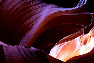
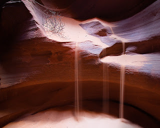
Upper Antelope Canyon is called Tsé bighánílíní, "the place where water runs through rocks" by the Navajo. It is the most frequently visited by tourists, due to two considerations. First, its entrance and entire length are at ground level, requiring no climbing. Second, beams (shafts of direct sunlight radiating down from openings in the top of the canyon) are much more common in Upper than in Lower. Beams occur most often in the summer months, as they require the sun to be high in the sky. Winter colors are a little more muted like the photo displayed here. Summer months provide two types of lighting. Light beams start to peek into the canyon March 15 and disappear October 7 each year.
When approaching upper Antelope Canyon, there is no obvious clue as to its location. The trail seems to end at the base of a red sandstone plateau about 20 yards high, but the sight of an Indian jewelry stall soon indicates its position - the entrance is a narrow curved slit in the cliffs only a few feet wide. Once inside, the temperature drops as much as 20 degrees as the visitor enters one of the most beautiful of all natural formations.
The sunlight filtering down the curved sandstone walls makes magical, constantly changing patterns and shadows in many subtle shades of color. Some sections of the canyon are wide and bright, while others are narrower and more cave-like, with no light reaching the sandy floor. After only 150 yards or so, the canyon becomes suddenly much shallower near the top of the plateau. It may take only 3 or 4 minutes to walk through, but the canyon is well worth the arduous trek or expensive journey required to get there.
Pictures taken here adorn camera shops and photographic manuals throughout the world, and usually there will be many people waiting with tripods and light meters trying to compose the perfect shot, and grumbling when other people walk in front of their two minute exposure. There are other equally short but pretty narrows further upstream, though these are not open to visitors.
Lower Antelope Canyon
Lower Antelope Canyon, called Hazdistazí, or "spiral rock arches" by the Navajo, is located a few kilometers away. The lower canyon is longer and deeper than the upper section, but also slightly more challenging, requiring climbing down ladders in some places to descend several sheer drops. It was here that 11 people were drowned in a flash flood in August 1997, when water 50 feet deep from a thunderstorm 5 miles away swept through the canyon, eventually deepening it by 4 feet.
Lower Antelope Canyon was closed for 9 months before reopening with improved safety features, and now all visitors must now be accompanied by a guide. Both parts of the canyon are still beautiful, but any sense of adventure or tranquility is long since gone - best to try one of the hundreds of other Southwest slot canyons for these qualities. The nearest alternative, free except for the standard Navajo hiking permit, is lower Water Holes Canyon, the section west of US 89.
Despite these limitations, Lower Antelope Canyon draws a considerable number of photographers, though casual sightseers are much less common there than in Upper.
The lower canyon is in the shape of a "V" and shallower than the Upper Antelope. Lighting is better in the early hours and late afternoon.
Access is controlled by the Begay family who have placed numerous ladders to help you get in and out of the canyon, probably close to a dozen in all. Thats why to enter this area is alittle bit expensive. To visit either part of Antelope Canyon is expensive. There is a fee of $6 for a standard permit required to enter Navajo territory, and an additional charge is due to the families who own the land around the canyons and regulate all access - the cheapest is currently (2011) $20 for the either the popular upper section or the longer lower canyon. This is the cost to travel to the canyons in a Navajo jeep; organized tours with a guide cost rather more. For the upper canyon the fee is paid to officials at the side of AZ 98 near the start of the track, and is now apparently only good for 2 hours, with longer visits costing an extra $5 per hour. The fee to enter the lower section is collected by attendants at the carpark near the canyon edge. These amounts will doubtless increase as the Navajo continue to exploit the popularity of the canyon.
How To Get to Antelope Canyon
Antelope Canyon, which is located in Page, Arizona, can be reached using three kinds of transportation mode. You can choose whether to use Bus, Flights or Train.
Traveling by CAR
Traveling from Grand Canyon go North on Highway 89 to Page, Az
Traveling from Utah go South on Highway 89 to Page, Az
Traveling from Navajo Reservation to Westbound on 98 to Page, Az
Traveling from Grand Canyon go North on Highway 89 to Page, Az
Traveling from Utah go South on Highway 89 to Page, Az
Traveling from Navajo Reservation to Westbound on 98 to Page, Az
Traveling by PLANE
Page Municipal Airport in Page, AZ - 928-645-4337
Grand Canyon National Park Airport
Sky Harbor Airport in Phoenix, AZ
McCarran International Airport in Las Vegas, NV
Page Municipal Airport in Page, AZ - 928-645-4337
Grand Canyon National Park Airport
Sky Harbor Airport in Phoenix, AZ
McCarran International Airport in Las Vegas, NV
Traveling by TRAIN
Nearest train station is in Flagstaff, AZ - Amtrak
Nearest train station is in Flagstaff, AZ - Amtrak
The road to Antelope Canyon is gated and only tour guides authorized by the Navajo Nation can enter. Several tour operators are licensed to take people into the slot canyons. Antelope Canyon Tours is Navajo owned and run, and uses only Navajo guides. They offer regular tours, special photography tours and one of the earliest tour times. Other companies also offer Antelope Canyon tours.
So let me congrat you to enjoy your travelling time, feel the nature tell their story to you
So let me congrat you to enjoy your travelling time, feel the nature tell their story to you


 11:03 PM
 Unknown


 Posted in:


